


Farmers Can Benefit From Tracking Water Use With Satellites
 July 25, 2024
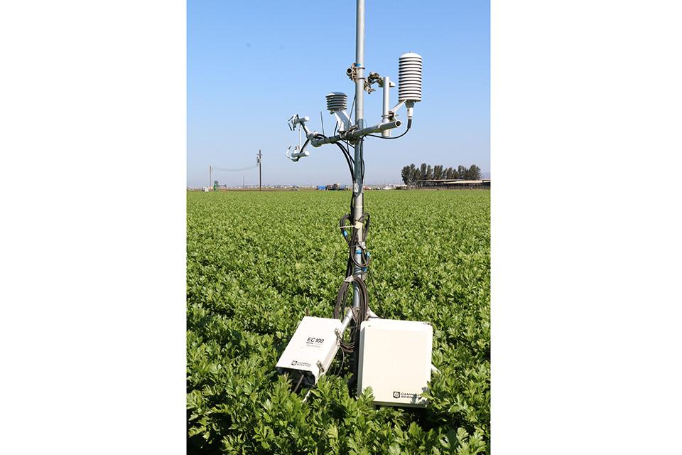
Meteorological stations can be used to directly measure crop evapotranspiration for comparison with satellite measurements.
Photo by Michael Cahn, UC Cooperative Extension

Communities throughout California have had to come together in recent years to address an important challenge: Develop and implement plans to manage groundwater sustainably. This communal task originates from the Sustainable Groundwater Management Act (SGMA), a law passed by the California Legislation in 2014. That year followed a multiyear drought that resulted in many wells in the state going dry as groundwater levels receded.
SGMA includes estimating the water volumes that recharge and are extracted from the underground aquifers. Estimates typically rely on computer models, groundwater level measurements, and pumping data.
However, an important component in estimating ground water use is the amount of water lost to the atmosphere by evapotranspiration (ET) from crops, rangeland, and wild lands.
Accurate Measures
Satellite based observation has become a critical tool for evaluating ET at the landscape scale. Imagery from Landsat, Sentinel, and other public satellites can sense different wavelengths of light that correspond to plant foliage, surface temperature, and soil moisture.


Using mathematical models, ET can be computed on a ¼ acre grid scale and aggregated across entire watersheds on daily to annual time intervals.
A traditional approach to determine groundwater use involves summing up pumping data from all the wells in a groundwater basin. Satellite data offers some advantages compared to using well data in terms of cost and accuracy. Well extraction volumes can be difficult and expensive data to collect over a season. A, and in some regions, wells are not equipped with flowmeters, or the flowmeters are inaccurate.
Using satellites to compute ET can also improve accuracy. Well extraction data does not estimate net water use of crops, also known as “consumptive use.” Drainage below the crop root zone due to inefficiencies in the irrigation system or scheduling eventually returns to aquifers that are unconfined by clay layers.
Hence pumping volumes can overestimate groundwater use in these cases compared to ET measurements. On the other hand, unirrigated or underirrigated crops and non-crop vegetation take up soil moisture, thereby reducing the volume of groundwater recharged from rainfall. Accounting for ET from these lands can guard against overestimating recharge to the groundwater supply.
Options Available to Growers
Processed satellite data for ET estimation on a watershed scale is increasingly available from private companies and public institutions. Free online platforms make satellite estimates of ET accessible to the public (eg. OpenET; IrriSat).
OpenET offers complete coverage across the western U.S. dating back to 2018 and supports six different mathematical models that derive ET from satellite data.
Each model has strengths and weaknesses. And so there is an option to calculate the ensemble average of all models together. A user can outline the boundaries of a specific field or farm to compute water use on a monthly or daily basis and can easily download data to spreadsheet files. Also, the platform provides data on precipitation, reference evapotranspiration, and normalized difference vegetation index (NDVI) which quantifies the health and density of vegetation.
Growers and other water managers are understandably interested in the accuracy of satellite-based estimates of crop ET.
One way to check the accuracy is to monitor crop ET for specific sites and crops using meteorological instruments installed on the ground and compare with satellite measurements. This type of analysis is ongoing throughout the West by researchers in various universities and institutions.
A recent evaluation of OpenET involving 152 ground stations found that the average monthly ET was within 17% of ground data. And on an annual basis, the average difference was about 11%. The collection of additional ground measurements, combined with an ever-increasing number of satellites, helps assure that remote ET monitoring will become increasingly accurate.
In summary, quantifying water use from groundwater supplies has always been a challenge in the west. As droughts have become more frequent in California urban and rural areas must rely increasingly on groundwater to make up for less availability of surface water. Careful monitoring and management of groundwater has become necessary so that this resource is available for future generations.
Luckily satellite data is becoming more accurate, useful, and accessible to communities developing groundwater management plans.
Subscribe Today For