Atlantic Hurricane Forecast Taken Up a Notch

This field of snap beans near Hastings, FL, lay tattered in the wake of Hurricane Matthew in October 2016. This kind of scene was common on farms around the Northeast part of the Sunshine State following the major storm. The 2017 hurricane season is just getting warmed up.
Photo by Bonnie C. Wells
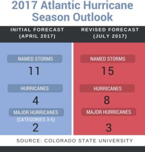
Back in April, noted Climatologist Dr. Phil Klotzbach of Colorado State University kicked off the 2017 Atlantic hurricane preseason prognostication parade by releasing an outlook that called for a below-average campaign – or at least one quieter than last year. The 2016 season was made noteworthy by Hurricane Matthew, a monster storm that spread billions of dollars in damage from the Bahamas, to Florida, and up through the Carolinas.
Fast forward three months later, and Klotzbach’s once fairly mild 2017 Atlantic hurricane forecast has taken a turn toward the more tempestuous. According to Klotzbach, climate conditions now appear much more conducive for tropical development than what was apparent at the onset of the season. “The odds of a significant El Niño in 2017 have continued to diminish, and most of the tropical and subtropical Atlantic remains anomalously warm,” Klotzbach noted in his latest report.
Klotzbach’s latest outlook falls more into line with NOAA’s predictions.
As of this posting, four tropical systems have formed in the Atlantic (Arlene, Bret, Cindy, and Don). Only Cindy made landfall, drenching the Gulf Coast and Lower Mississippi Valley.
Along with the increase in storm potential, comes a higher chance of a land-falling storm, Klotzbach stated in his report. “The probability of U.S. major hurricane landfall is estimated to be about 120% of the long-period average.”

Klotzbach and his team will continue to monitor the situation and revise the forecast as necessary. The next update is slated for early next month.
Just a reminder, Atlantic hurricane season technically reaches its peak in mid-September.


